Monday, December 19, 2016

Johnson Ridge and Robert A Whipple State Nature Preserves


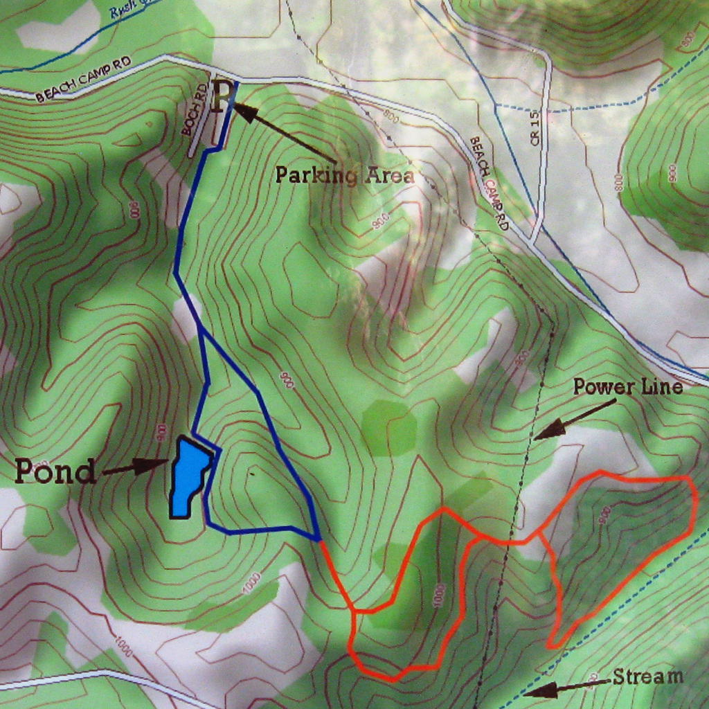
Johnson Ridge State Nature Preserve is located off of State Rt 247 about halfway between West Union and Seaman - a name that seems to cause people to giggle.  Go east on Unity Rd 1.7 miles and turn right at the sign onto a gravel road.  In a couple tenths of a mile you will see the above sign on the left. There is room to park three or four cars between the road and the fence.  The trail is a short loop on the end of a long stick and is 1.2 miles.

The trail initially heads away from the road before curving left and roughly paralleling the road you just traveled.  The first third of the "stick" part of the trail goes through transitional forest.  It is a few years older than an early successional forest (which has lots of small trees and dense undergrowth as seen in the photo above), but most of the large trees are tulip poplar so it is not a mature forest (mostly oaks, hickories, beech, and sugar maple, although some tulip poplar, red maple and other trees show up in small numbers).  When I hiked on 10/26/2016 the poplars had already lost most of their leaves. And then ............. BOOM!

The undergrowth is gone, the species of trees changes, and start getting bigger.


Suddenly you see much farther, fall color lasts longer and, in the spring there are more wildflowers.  There are also large fallen trees and limbs that provide places to sit and observe. Maybe read a little, maybe think about things like, "Why do I waste my time reading this blog?"


One final note on the trail itself:  If you have hiked this trail earlier than 2015, and you lost the trail because the stream crossing was too muddy and you had to find a place to cross that was less steep and/or muddy and you couldn't find the trail because it is a seldom-visited Preserve, and the trail was too new to be visibly worn, and there are no blazes on the trees (surely I can't be the only one who had that problem), there are now bridges.  The trail is kind-of hard to see when a lot of leaves have fallen, so you need to look for the remnants of blue flagging tied to trees.  And now onto ......


It is as difficult to find Mr.Whipple's  Preserve as it is to resist the urge to squeeze the Charmin. (Note to younger readers: That is a cultural reference.)  It is on State Rt 247 about the same distance south of West Union that Johnson Ridge was to the north.  OK, maybe a little further from West Union, but I like the symmetry since they are both described in the same post. If you are approaching from the north, once you are driving downhill and there are trees on both sides of the road (I swear this is the only occurrence of that) you need to look for the above sign on the left.  You have to drive past it and turn around to park on the east side of Rt 247.  Fortunately there is a vacation cabin rental place on the right just past The Whipple with a circular drive to turn around in.  If you are approaching from US 52 to the south you need to be extra-vigilant looking for the vacation cabin rental place on the left and be ready to pull over as soon as the shoulder is wide enough (only a couple hundred feet at most).  You probably won't see the sign for The Whipple.  Unlike South Bound Travelers (my first Al Di Meola reference) northbound travelers have to drive further to turn around, and then have to turn around again to get on the proper side of the road.  I wish someone had told me this before I first Walked the Whipple.  Aren't  you glad I didn't make as many jokes earlier about Seaman?  Time to start hiking.


This trail is a long loop on a short stick - the opposite of Johnson Ridge.  It is also entirely in mature forest.  That, as we learned earlier, means that there are lots of fallen trees on the ground.  Unfortunately, this forest is an over-achiever in that regard.  There were strong winds in the summer of 2016 that caused many trees to uproot or have their tops broken off.


This picture is worth more than a thousand words to me.  Brief explanation:  The 30"+ diameter white oak uprooted.  The roots on one side bent but did not break, basically spring-loading the tree.  When the top of the tree was cut, reducing the weight and leverage that held the tree down, it sprang back up.  Scary and dangerous as hell if you are the one cutting it.

The trail was cleared so it was an easy hike.  I tried to imagine what it would have been like to be there when a wind strong enough to knock over that many large trees was blowing.  The debris from that storm will be there for many years.  Unfortunately, the opening created by the fallen trees will expose other trees to winds they were previously sheltered from, causing more damage.  Nature's own clear-cut.  It will be interesting to see the forest's response to this natural clearing.

A brief description of the trail itself:  The short stick goes up the west slope to the ridgetop.  The trail follows the ridge south and provides a few glimpses of the Ohio River (even with leaves on the trees) before winding down the east side of the slope.  It goes back to the north about midway down the slope.  This is said to be a decent place for spring wildflowers.  The one time I was here in the spring I was early, so I cannot attest to this.  After a half mile or so the trail gently climbs back to the beginning of the loop and the downhill walk to the car.

Tuesday, October 4, 2016

Boch Hollow Nature Preserve

Boch Hollow Nature Preserve is located about ten miles north of Logan, OH, just off of SR 664 on Beech Camp Road.  Or maybe it is on Beach Camp Road.  The ODNR page spells it the latter way, but the map directly below that spells it the former.  I don't remember how it was spelled on the street sign.  Anyway, the parking lot is less than a mile from SR 664.


There is no trail map on the ODNR page and there were no maps in the kiosk so if you want a map to have on the trail, take a picture of the one displayed in the kiosk.  I, as you have probably already figured out, am not that smart.  Bob and Deb Platt of TrekOhio.com were smart enough.  They also take better photos than I do.  And they hike more.  And they post more.  And why are you wasting your time reading my blog when you can start exploring their blog.  I've spent hours there.  Anyway, below is their photo of the trail map from the kiosk.  I told you they take better pictures than me.


The Blue loop is about 1.5 miles long.  The beginning and end follow a gravel road and mowed field.  The right portion of the loop (as you are hiking it) goes by the pond.  It is a nice place to sit enjoy the quiet that many times seems to be becoming a rare commodity in the southern portion of the Hocking Hills region.  As you pass the pond the trail turns left into the woods and ascends a hill steep and long enough to get one breathing a little heavier.  The rest of the hike is easier.

You are now at the junction of the Blue and Orange loops.  Turning left takes you back to the beginning.  Take a right and follow the orange trail.  There are other trails being constructed (in September 2016) and are taped off.  Ignore them even if the tape is on the ground.  When the new sections are open they will pick up the tape.  If the map in the kiosk looks different than the one above then my post is out-of-date.  Of course you will probably read this before you hike there and not while you are hiking (for God's sake don't stare at your phone while you are hiking) so you won't know if you've wasted time reading this post until you get there.

EDIT:  The new trails are open. There is now a trail map on the ODNR page.  Since this post refers to the old trails I'll post the new map at the end.

Now, what was I typing about?  Oh yeah..... hiking.  The trail climbs to the top of the ridge and reaches the first split in this loop.  As always when hiking loops, go right.  The trail briefly stays on the ridge top and then slowly descends the other side.  There is a nice, quickly deepening hollow opening on your right.  The trail turns left and levels.  The other closed trails cross the trail like a friendly cat walking between your legs.  Never go hiking with a cat.  Go right at the junction and hike towards something I actually took a picture of.


There is not a lot going on in late September.  Except goldenrod.  Goldenrod has got it going on.  You will walk through this field for just a short time at the beginning of this loop.  It seemed like it was nothing but goldenrod and dogwoods.  Dogwoods can turn a brilliant red in the fall but these trees seemed stressed and not likely to put on a stunning display.  When you leave the field and enter the woods the trail goes diagonally downhill into the hollow that we saw at the beginning of the Orange loop.


You can't tell from the photo above, but this is actually the most picturesque part of the hike. The valley is narrow enough that there is a view uphill on both sides of the trail.  It would be really nice when fall color is upon us.  Hopefully there will soon be other trails in this valley with better photographers on them.  OK, I admit it - I wandered a little and saw some of the closed trail.  Who didn't see that coming.

The trail continues downstream towards the road that got tired of people not knowing whether it is called Beech Camp or Beach Camp and has by this point changed its name to Bremen Rd.  That useless fact has nothing to do with hiking.  The trail turns left and climbs back up to the field of goldenrod.  Another, longer walk through the field and then the other half of the first split of the Orange loop.  Then it is all down hill on the other half of the blue loop.

A recess cave on the right as you return on the Blue loop.

Boch Hollow Trail Map 

I haven't figured out how to get a PDF to show up in the blog so a link to it will have to do.

Friday, February 26, 2016

Englewood MetroPark

Englewood is one of the Five Rivers MetroParks.  It is northwest of Dayton and it is where I hiked on Saturday, February 6, 2016.  I only hiked in the East Park, hiking most of the Red (1.2 miles) and Green (3.8) Trails.  As with the other MetroParks several different shorter trails share a portion of the longest (in this case Green) trail, although here the shorter trails cover more unique ground.

I started at Point 16 because I saw the sign and an open area across the road.  In hindsight, it is probably best to park at the area marked "Trailhead" on the map.  Who knew?  Anyway, the first section of the Red Trail heading away from the road is just early successional forest, small trees and no spectacular geologic or botanical features.  In other words - kind of boring, especially in the winter.  I turned right at point 17 onto the Green Trail and the trees got a little bigger and the trail had some turns and dips and rises on its way to Oaks Falls.


It's kind of hard to tell from the picture but there is not really a lot to see here.  OK, that is exactly what you can tell from the picture.  It is just a small stream making a short fall without a good area from which to view it.  So I did not linger for long, but continued on my way to Patty Falls.


Patty falls is actually two waterfalls.  The Green Trail goes above them and you can take the Purple trail down to view them from below.  The lower pic is not my best work but the lighting was poor and it was a rather small waterfall and there was something in my eye and.............  Anyway, you can stand close enough to the bigger fall to feel some of the spray, not that you would want to in February.


After leaving Patty Falls the trail goes through a fairly young section of forest that has occasional large trees known as "wolf trees."  These are trees that grew up in a field when there were no other trees close by.  Not only are they larger than the other trees that have more recently grown around them, they have lower limbs (or the dead subs of lower limbs that have been shaded out) and have a greater horizontal spread than a typical forest-grown tree.  Here in Englewood, most of the wolf trees are white oaks.

Beyond point 24 the trail is on a boardwalk through the Pumpkin Spice Ash and Swamp Forest.  I'm sure the emerald ash borers appreciate the fact that Five Rivers MetroParks has chosen to inject pumpkin spice flavor into the ash trees.  Oh wait, its just pumpkin ash - no spice - and they are trying to save them because pumpkin ash is a species that is rare in Ohio.  I may come back when leaves are on the trees to get a better feel for the composition of this swamp forest.  In addition to the pumpkin ash I noticed some hickory (shellbark I presume) and not many sycamore or cottonwood that you would expect closer to the river.

I took a left at point 5 and continued on towards Martindale Falls, named after Wink Martindale, the host of the world famous TV game show Tic-Tac-Dough.  The woods along this stretch are a bit more mature on the left, while on the right a bridle trail goes through a field reverting to forest.

Martindale Falls from above

 
Martindale Falls from below

The trail away from the falls is parallel to the trail to them but at a lower elevation.  The area to the right is not part of the park but there are trails and occasional hikers.  This is a nice stretch of woods that continues until you reach point 7 and turn right.  There the trail gets closer to the Stillwater River and goes through the sycamore, cottonwood, and box elder of the riparian forest.  Along the way there are many large, interestingly shaped sycamores.  Then the trail goes through a mile-long mud puddle.  That is how you know you are getting close to Englewood Lake.

 
It is obviously a man-made lake created when they excavated soil to use to build Englewood Dam.  They have since un-dammed the river and have created channels to and from the river to give the lake a fresh supply of water.

I'll review Aullwood Garden and South Park (yes, that is what it is called) when I visit them in the early summer.

Monday, February 8, 2016

Twin Creek MetroPark


As the picture shows Twin Creek is part of the Five Rivers MetroParks which are in the Greater Dayton are.  Twin Creek is southwest of Dayton.  There are two larger loop trails and these are made up of smaller loops.  For example, the Orange Trail is 6 miles and there are five other trails between 1.1 and 2.9 miles that mostly coincide with the Orange Trail except for a short connector section to make them loops (look at the map to see how bad of a job I did explaining it).  The two other parks in the system that I have hiked also have a similar trail layout.

On Saturday, January 30, I hiked most of the 6-mile Orange Trail and the 2-mile White Trail.  The south parking lot on Chamberlain Rd is the trailhead for both trails so that is where I parked.  I will always park there because of an experience I had previously.  I hiked the Orange trail on a day when it was 15 degrees when I started hiking and didn't get much warmer.  I also started at the south lot and hiked the half of the loop along the creek first.  I dressed for the weather and was fine until I hiked out of the valley and to the top of an exposed and very windy hill.  The other parking lot is called High View and is not misnamed.  Cold temperatures and strong winds do not mix well.  Now when I hike (no matter what the weather) I avoid the High View by turning left at point 10 and follow the Blue Trail to point 1.

But enough about me, on this hike the temperature was about 30 degrees to start, warming to the 50's by the time I finished.  The mud was frozen for the first half of the Orange Trail and a sloppy mess after that.


I started out going to the right (counterclockwise).  The trail goes through a slightly hilly area that is reverting to forest.  There is a lot of cedar here.Then the trail reaches a level area.


This area has been mowed recently, although hopefully this will be allowed to follow the path (pun intended) of the hillier areas to returning to forest.  But you don't have to wait because the trail turns right and enters existing forest and passes the remains of the 2000 year old Carlisle Fort.


The trail continues along as the ravine on the right gets deeper.  It is a pleasant and scenic hike.  Don't let my lack of pictures dissuade you of that. The trail then winds down to the creek that gives the park its name.  It looks something like this:


That picture was taken looking downstream.  The trail goes upstream with the creek on your right and a field on the left.  After you pass point 7 the trail crosses a small stream.  It was still frozen and very scenic.

The trail goes along the creek through a riparian forest.  The riparian zone is the lowland along a creek or river that occasionally floods, usually in the spring. This area is mostly cottonwood, sycamore and box elder and it continues for the next mile.


Some of the sycamores are large and contorted into strange shapes.  Sometimes the sun is angled correctly and you can capture the bright white limbs against the deep blue cloudless sky.

A couple more pictures of Twin Creek


I turned left at Point 10 and as the trail went uphill the tree species changed.  By the time I got to the top of the short climb uphill I was surrounded by oaks and maples and beeches.  The band was back together.  After a couple tenths of a mile of decent upland hardwood forest the trees start getting smaller and there are more black cherry and black locust.  Beyond that you get back into the cedar similar to how the hike started.  You just walked backwards in time (or you would have had you been with me).  The forest type changed and then got progressively younger.  Nothing earth-shattering but it is one of the things that I pay more attention to on winter hikes.

And then, after turning left at Point 1 to avoid High Winds...... err, View and Passing Point 2 the process is played out again, this time the forest gets older as you go.  This cycle happens several more times with a trip by Dogwood Pond thrown into the middle of it all.

Partially frozen Dogwood Pond


After passing Point 5 the trail stays in the cedar/ early successional forest and, as it was now over 50 degrees, gets progressively muddier.  It was like walking back in time to when animals first climbed out of the ocean.  Perhaps a bit of an exaggeration and over-dramatization but at times I felt like I was ice skating, except that I didn't fall.  Can't say the same about my futile attempts at skating.

After a brief stop at my car to dump all the layers of clothing I had shed as the temperature increased by 20 degrees I crossed Chamberlain Rd into the southern section of the park.  This used to be a Boy Scout camp until 1991, and was purchased by MetroParks in 1997.  There are still a lot of remnants of human activity in this section of the park.  I stayed on the White Trail instead of the slightly longer Purple Trail because I remember the latter as being muddier and I had enough of mud at this point.

At this particular time I should probably say something about emerald ash borer, so here it goes:  EAB has killed millions of ash trees and many of them are along the Silver Trail.  Ash trees get brittle and fall a part quickly after they die (As opposed to oaks, which can retain dead limbs for many years. I will talk about this in an upcoming post about Englewood Metropark).  Until they remove these trees they are a hazard, especially when it is windy, i.e. March and April.

So, why am I bothering to mention this muddy hazardous hike?  Because a year and a half ago it wasn't muddy or hazardous when I hiked it.  It was a sunny late October day, 50-something degrees with a light breeze rustling the multicolored leaves before blowing through the few remaining hairs on my head.  It was perfect weather.  I had hiked at nearby Germantown Metropark and had the time for another couple miles of Fall Color.  I had just feasted on beef jerky and coffee on the ride between hikes.  In short, it was the kind of day that could make (insert your favorite horrible, devastated landscape) seem beautiful.


And what do I post a picture of?  A partially frozen stream that is flowing under the ice into Lake George.  Obviously not a lake - just a tiny little pond.  I didn't name it so don't blame me.  It was the most scenic photo I took on this late January day.  The only other option was a photo of a really old, mostly dead sycamore.  Trust me, between Point 14 on the map and Lake (Pond) George there is some good fall color at the right time of the year.

So, this blog is supposed to help people decide when to hike.  Don't hike Twin Creek in the winter when it is above freezing - it is too muddy.  If you hike in the winter when it is well below freezing avoid High View - too cold and wind-chilly.  Otherwise, watch out for falling ash trees and limbs in the southern section.

  A photo of a really old, mostly dead sycamore
 

Monday, February 1, 2016

Cantwell Cliffs

Cantwell Cliffs is part of Hocking Hills State Park, although it is about 15 miles from Old Man's Cave and the campground.  The map can be viewed by going to the above link and clicking on the Cantwell  Cliffs Trail Map link.  It is a PDF and I have not had any luck linking to PDFs so two clicks are required.  The map online is not as good as the one on the trail signs in the park.  In addition to being "cartoony" it is out of date.  The trail to the right of the shelter house is no longer used and there is one other difference I will mention shortly.

To start the hike you walk down hill (and eventually down steps) past the shelter house to the edge of the cliffs.  If you go to the right you can view the world from above first.  I chose to descend into the hollow.  Following this route and turning left brings you to this:

The trail goes between the cliff and the rock.  The out-dated map online refers to this as Fat Woman's Squeeze.  That name is no longer used in the park.  It is actually not as much of a squeeze as it appears in the picture.  Personally, even though I weigh &% pounds more than when I first hiked here #$ years ago, I do not think it is a squeeze at all, although I do find myself wishing that I had worn a smaller backpack.  Stupid bulky backpacks.

Anyway, after you hiked the portion of the trail that is definitely not called Fat Woman's Squeeze you will find yourself looking at a waterfall.  It is not a particularly large fall but it is the largest of the three in the park.  There used to be paths going behind the waterfall and over rocks and along sandy slopes before going downhill and joining the gorge trail.  That is no longer an official trail but the odds are pretty good that you will see someone there anyway.  The official trail curls to the right around that half of Fat Woman's Squeeze if it was still called that to the proverbial fork in the trail.  Going right the trail follows the base of the cliffs.  Going to the left is the Gorge Trail Loop.  This trail provides distant views of the waterfalls and cliffs at the beginning and a wetter, greener, lusher landscape along the left side of the loop compared to most of the trails in Hocking Hills State Park.  On this day I skipped the Gorge Trail and took a right.

After only a couple minutes you come to the second waterfall.  It had only been below freezing for 36 hours before this picture was taken so the icicles are nowhere near their peak. The cones at the bottom of the falls weren't either.


Now is a good time to talk about why I like Cantwell Cliffs and what makes it different than other places in the Hocking Hills region.  It wasn't obvious at first to me, so I will share it with you and spare you the hours of deep thought and personal reflection that it took for me to figure it out. It is that you can walk along the bottom of the 80' to 100' tall cliff, touching the cliff wall with your hand and feeling the splatter of the waterfall on your face, and 10 to 15 minutes later you are walking along the top of the cliff with an obstructed view of the trail below.  There are higher cliffs, bigger falls and better views (see Conkle's Hollow) in the region but being able to quickly transition from the bottom to the top is rather unique.  You brain is able to piece together the view from below and above into one panorama better than any camera and software can.  Or maybe I just can't take pictures worth a damn.

Anyway, the trail goes past the base of the waterfall and climbs up some steps, many of which are nowhere near horizontal.  (In the middle of the climb there are more steps to the right that lead to the top of the cliff.  If you won't to hike up and experience an even quicker transition from bottom of the cliff to the top you can.  Just be sure to come back down and continue the hike.)  It had started to snow a little harder about this time and that, combined with the interesting views of the cliff wall on my right and the small stream from the waterfall increasingly further below me on my left kept my eyes occupied.  Before I knew it another small hollow had opened up in front of me and their was the third waterfall.  The trail again goes by the base of the waterfall.  I wanted the perfect picture but the waterfall was too tall to get it all in one pic and the trail was never far enough away before it started climbing up several more angled and now snow-covered steps,  This is actually a bigger climb than the one after the second waterfall and you are only about twenty feet from the top of the cliff.  This part of the trail is level so you can concentrate on the view of the gorge as it widens to the left and a wide hollow approaches from the right as you follow the cliff face in that direction.  I tried to concentrate on the view but all I could see is snow and I was distracted by the smell of woodsmoke.  I was sure that this was a hallucination.


The trail continues around to the right but you don't get to see the stream (and waterfall) that created this larger hollow as you are near the park boundary.  In my younger days I did hike down to it and was disappointed.  The waterfall was only 10 -15 feet and did not have much water compared to the other waterfalls.  There was also a washing machine near the bottom of the fall.  If you stay on the trail you will be spared this disappointment as the trail climbs some mostly level steps to the top of the cliffs.  Again, there is a nice view from up here, especially when it is snowing.  I love winter hikes.  As I approached the rest shelter I had forgotten that I smelled smoke earlier.  I actually was startled when there was suddenly a little kid standing six feet from me.  There was a family of three that had lit a fire in the fireplace of the rest shelter.  It is a small shelter and only has three walls and I had no memory of there being a fireplace but, there they were, starting to prepare lunch.

Right after you pass the shelter the third waterfall comes back into view.  The view is spectacular.  At most of the waterfalls in the region the cliff walls along the side of the stream are vertical half of the distance and then slope the rest of the way to the stream.  Here they are vertical nearly the entire distance.  Everything is further below you, but as far as horizontal distance everything is closer to you.  There are trees that are only thirty feet from you that are eighty feet tall before their first branches.  Sadly, I have not been able to capture this in a pic.  There is just no perspective when you are standing at the edge off a cliff staring down eighty feet of tree trunk. I promise you won't be disappointed when you see it in person.

The view is repeated at the second waterfall.  The trail goes back to the base of the steps that lead back up to the parking lot.  There is a sign straight ahead saying that it is not a trail and is illegal to hike off the trail.  Years ago there was no such sign and I did hike to the top of the first waterfall.  The view is not as spectacular because the hollow is wider and there are no trees growing near the cliffs.  Even though there was no sign telling me not to I still only hiked there once, so there must not be much to see.  In this case it is best (and safest) to obey the sign and either head back down and hike the Gorge Trail Loop or return to the parking lot. 

So, if you stop and stare a lot and hike the Gorge Trail it would be about three miles and it would take a little over two hours.  Skip the Gorge Trail and stare at stuff less (hard to do your first couple times here) and you can cut the time and distance in half.  This would matter if you had limited time and were trying to go to several of the lesser-visited attractions in the region (Rock House, Cantwell Cliffs, Rockbridge, and Clear Creek).

Sunday, January 24, 2016

Clear Creek Metro Park

On Sunday, January 17, I hiked at Clear Creek, one of the Columbus and Franklin County Metro Parks.  There are many creeks named "Clear" and several parks named "Clear Creek" and several park systems with "Metro" and "Park" in their name, although some of them combine the two words into one.  To add to the confusion, this particular Clear Creek Metro Park is located in Hocking County, at least 40 miles and a couple counties from Columbus and Franklin County.  It is located west of US 33, east of Lancaster.  Fortunately, the trails are well-marked and a lot less confusing than the name and location.

Take Clear Creek Rd (County Rd 116) off of US 33, and after a little less than a mile there wil be a sign advising you to slow down to 15 MPH.  The road narrows because of a rock wall along the right and a large slump block leaning over the road on the left.
Leaning Lena.  Picture from the Park's website.
Trucks do use this road and those traveling in the opposite direction will be in your lane.  While this can be scary if you are not expecting it (sorry I ruined it for you if you like a good scare), it makes a great "Welcome to the park" statement.  Another half mile or so gets you to the Creekside Meadows Picnic Area parking lot.  I usually park here and either take the Cemetery Ridge Trail (2.5 miles) and return via the Creekside Meadows Trail (1 mile each way) or vice versa.  Since I was only going to hike the Fern (2.1 miles) and Hemlock (1.5 miles) and then go on to nearby Cantwell Cliffs in Hocking State Park, I drove another half mile or so to the Fern Picnic Area and parked there.  There are several other places to pull off the road should you want to try your luck fishing.  Clear Creek is regularly stocked with fish and is quite popular right after the stocking.  The banks are lined with fishermen.  They are standing on each others shoulders.  They have nets and catch the fish as they are being released.  At least that is what I have been told.  I have not been there and seen more than one or two people fishing.

Anyway, the Fern Trailhead is across the road from the parking lot.  After a zigzag start the trail goes up a gentle slope on the left side of a hollow.  The forest is a mix of hardwoods and hemlocks, most of the hemlocks are deeper in the hollow, but some of them have managed to climb the slope a little ways.  After about a half mile you come to the loop portion of the trail.  To the right the trail continues along the hollow 1/2 mile to the Hemlock Trail and another 1/4 mile up to the Cemetery Ridge Trail.  To the left it is 3/4 mile to Cemetery Ridge and 1 mile to the Hemlock Trail.  I took the long way.

When you take the trail to the left the slope increases and except for one short section you are walking uphill until you get to the upland meadow (the light green on the map).  There are many reasons to stop and catch you breath: To the right you can look through the woods at the hollow you were previously walking along and to the left you can look out over the treetops of the Clear Creek Valley.  It was snowing lightly when I was hiking making the view that much more enjoyable.  Eventually you reach the ridgetop with the meadow on your left and the woods sloping away on the right.  In the summer the meadow is alive with flowers and butterflies and birds.  I do most of my hiking in the fall, winter and spring so I tend to pick up the pace along stretches like this.
As I mentioned earlier, it was snowing lightly, and by the time I got to the ridgetop the ground was fairly well covered with snow.  I ignored the meadow to the left and looked at the woods sloping away to the right.  After you pass the Cemetery Ridge junction the trail heads downhill (finally) into the woods to:
It was still snowing and the flakes of snow were getting larger.  All the footprints of the hikers ahead of me continued down the Fern Trail to the parking lot.  The Hemlock Trail was virgin ground.  Well, at least it has been for the last 30 minutes.  The Hemlock Trail walks around the top of the hollow that the Fern trail followed at the beginning of the hike.  It then goes uphill and enters another deeper hollow.  There are other smaller side hollows and some small ups and downs along the way.  The trail passes through several groves of hemlocks that give the trail its name.  The trail eventually goes to the bottom of the hollow and follows the stream back to Clear Creek Rd.  I'll let the pictures narrate the rest of the hike.
The snow is just starting to accumulate on the branches of the hemlocks
Here the trail goes through the hemlocks


This tree has been dead a long time.  It took even longer for the tree to grow that large.  Those rocks have been there even longer still.

Looking upstream from a bridge

The trail goes along the left of the stream until it reaches Clear Creek Rd