There is no trail map on the ODNR page and there were no maps in the kiosk so if you want a map to have on the trail, take a picture of the one displayed in the kiosk. I, as you have probably already figured out, am not that smart. Bob and Deb Platt of TrekOhio.com were smart enough. They also take better photos than I do. And they hike more. And they post more. And why are you wasting your time reading my blog when you can start exploring their blog. I've spent hours there. Anyway, below is their photo of the trail map from the kiosk. I told you they take better pictures than me.
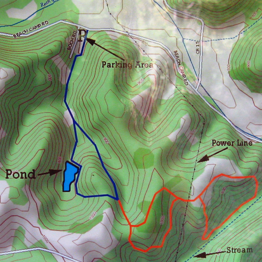
The Blue loop is about 1.5 miles long. The beginning and end follow a gravel road and mowed field. The right portion of the loop (as you are hiking it) goes by the pond. It is a nice place to sit enjoy the quiet that many times seems to be becoming a rare commodity in the southern portion of the Hocking Hills region. As you pass the pond the trail turns left into the woods and ascends a hill steep and long enough to get one breathing a little heavier. The rest of the hike is easier.
You are now at the junction of the Blue and Orange loops. Turning left takes you back to the beginning. Take a right and follow the orange trail. There are other trails being constructed (in September 2016) and are taped off. Ignore them even if the tape is on the ground. When the new sections are open they will pick up the tape. If the map in the kiosk looks different than the one above then my post is out-of-date. Of course you will probably read this before you hike there and not while you are hiking (for God's sake don't stare at your phone while you are hiking) so you won't know if you've wasted time reading this post until you get there.
EDIT: The new trails are open. There is now a trail map on the ODNR page. Since this post refers to the old trails I'll post the new map at the end.
Now, what was I typing about? Oh yeah..... hiking. The trail climbs to the top of the ridge and reaches the first split in this loop. As always when hiking loops, go right. The trail briefly stays on the ridge top and then slowly descends the other side. There is a nice, quickly deepening hollow opening on your right. The trail turns left and levels. The other closed trails cross the trail like a friendly cat walking between your legs. Never go hiking with a cat. Go right at the junction and hike towards something I actually took a picture of.

There is not a lot going on in late September. Except goldenrod. Goldenrod has got it going on. You will walk through this field for just a short time at the beginning of this loop. It seemed like it was nothing but goldenrod and dogwoods. Dogwoods can turn a brilliant red in the fall but these trees seemed stressed and not likely to put on a stunning display. When you leave the field and enter the woods the trail goes diagonally downhill into the hollow that we saw at the beginning of the Orange loop.

You can't tell from the photo above, but this is actually the most picturesque part of the hike. The valley is narrow enough that there is a view uphill on both sides of the trail. It would be really nice when fall color is upon us. Hopefully there will soon be other trails in this valley with better photographers on them. OK, I admit it - I wandered a little and saw some of the closed trail. Who didn't see that coming.
The trail continues downstream towards the road that got tired of people not knowing whether it is called Beech Camp or Beach Camp and has by this point changed its name to Bremen Rd. That useless fact has nothing to do with hiking. The trail turns left and climbs back up to the field of goldenrod. Another, longer walk through the field and then the other half of the first split of the Orange loop. Then it is all down hill on the other half of the blue loop.
 |
| A recess cave on the right as you return on the Blue loop. |
Boch Hollow Trail Map
I haven't figured out how to get a PDF to show up in the blog so a link to it will have to do.
No comments:
Post a Comment